


KNRM Helpt app for iPhone and iPad
Developer: Koninklijke Nederlandse Redding Maatschappij (KNRM)
First release : 29 Aug 2018
App size: 71.79 Mb
KNRM Helps, the official app of the Royal Netherlands Sea Rescue Institution (KNRM), allows you to register your vessel and Sail Plan and track your trip on your smartphone.
Follow the registration process to start using the app. You may either plan and file your trip (Sail Plan mode) or just activate the tracking function when starting your trip (Track only mode).
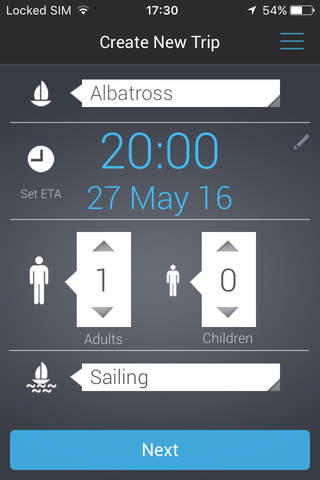
For filing a planned trip choose your vessel, determine the Estimated Time of Arrival (ETA), enter the number of persons on board and the activity type. After choosing the emergency contact(s), select a start point, an optional waypoint and the end destination in the built-in nautical maps. Once this is completed an optional checklist can be managed and you are ready to set sail. You, your emergency contacts and eventually the SAR authorities will be automatically alerted following a time scheme after the journey exceeds the ETA in Sail Plan mode.
Pressing Set Sail in Sail Plan mode or Start in Track only mode will register the trip details with KNRM’s server and will activate position reporting in the app. At regular intervals, the app will send a position report to the server.
At any stage during the trip you can end your trip, revise the ETA, number of people on board or the destination.
Use the KNRM Helps app to:
- Improve maritime trip planning with Electronic Navigational Chart (ENC) data.
- Quickly start tracking your trip using the Track only mode with at a touch of a button. Change the recording interval to save on battery consumption when your tracking is in progress.
- Find nearby information on VHF channels, ports, KNRM lifeboat stations, waterways and junctions, diving spots, bunker stations, water sport shops, shipyards and repair shops and boat rental companies.
- Give friends and family peace of mind ashore by sharing your real-time location on a live map, and allow them to track you while you’re on the water.
- Access location-based, real-time weather and water info when planning your trip or when your trip is in progress.
- Check valuable maritime safety information when both online and offline.
- Create or manage your own personalised checklist to be included as part of your Sail Plan before departing.
- Activate an Emergency or Assistance call by touching the Call for help button while your trip is in progress (iPhone only, not with iPAD).
Manage your profile, vessel, checklist and emergency contact information.
Continued use of GPS running in the background can considerably decrease battery life while in use.
Please note:
This application’s functionality and the information it contains are published on the understanding that end users are to apply their own knowledge and skills in the use of said application.
Maritime safety is an extremely serious matter. In an emergency this application’s function and information are not meant to be relied on exclusively. In addition, other reliable information and help from third parties should be looked for and made use of.
This application can provide valuable coordinates of the user’s position, as determined by the mobile device used and the GPS system. Mobile devices and their supporting telecommunication networks are, however, not reliable and there is a real chance of loss of connection between the mobile device and the mobile network and / or the GPS system. Nor is there any guarantee that the connection between your mobile device and mobile networks will be uninterrupted. The user hereby agrees to and accepts all risks involved in the use of this application.